Home
Up
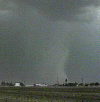
AZ July 7 95
Arizona Thunderstorm Chasers
![]()
This is a collection of pictures I took this year while storm chasing with the Arizona Thunderstorm Chasers (AZTC). AZTC is a research program at Arizona State University, Department of Meteorology, and is run by Dr. Randy Cerveny. It's purpose is to gather data on the poorly understood Arizona desert monsoon thunderstorms, and to assist the NWS with NEXRAD radar ground truth, damage surveys, and real-timer observations. AZTC is equipped with a department van and two sets of meteorological equipment. Two teams can thus go out... one in the van and one in a private car... and radio contact is maintained between the teams and a team member at the National Weather Service forecast center via 800 MHz SMR radio.
![]()
July 12, 1995 Chase
 July 12, 1995 was scheduled to be a practice chase starting at
4PM. As it turned out, a large thunderstorm developed NE of Tucson and propagated
northward. It produced a gust front that moved through the Phoenix area kicking up
isolated cells along the front. The cells were high based and produced brief heavy rain
and a number of wet microbursts, at least one of which produced damage in Chandler, AZ.
July 12, 1995 was scheduled to be a practice chase starting at
4PM. As it turned out, a large thunderstorm developed NE of Tucson and propagated
northward. It produced a gust front that moved through the Phoenix area kicking up
isolated cells along the front. The cells were high based and produced brief heavy rain
and a number of wet microbursts, at least one of which produced damage in Chandler, AZ.
![]()
July 30, 1995 Chase
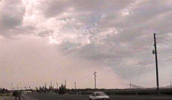 July 30, 1995 was a hot day with storms advancing towards the valley from the north and
southeast. We went to the Sun City area anticipating development from the expected
convergence... which unfortunately didn't happen. However, a large dust storm (haboob)
crossed the valley from south to north, and I got a picture showing the classic shape of a
gust front crossing the desert. This storm had winds in excess of 40 knots at sky harbor.
July 30, 1995 was a hot day with storms advancing towards the valley from the north and
southeast. We went to the Sun City area anticipating development from the expected
convergence... which unfortunately didn't happen. However, a large dust storm (haboob)
crossed the valley from south to north, and I got a picture showing the classic shape of a
gust front crossing the desert. This storm had winds in excess of 40 knots at sky harbor.
![]()
last update 07/24/95
![]()